


I sentieri dell'Antola 1:30.000
€8.00
In stock
Product code
CM059
Autore:
Infocartografica
Editore:
INFOCARTOGRAFICA

Hiking map of the Antola Regional Natural Park.

Spesa minima per la spedizione gratuita: €50.00
NOTA: Valido solo per spedizioni in Italia
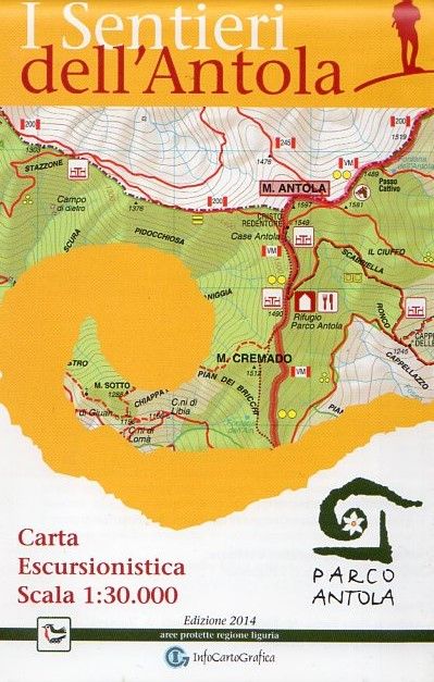
Hiking map of the Antola Regional Natural Park. Created on behalf of the Antola Park Authority: on the front there is the hiking map with the paths and some specific tourist information, on the back there is the tourist information (use, points of interest, accommodation), a table with the description and characteristics of the paths as well as the altimetric profiles of the main paths. Printed on waterproof and tearproof support. Monte Reale, Vobbia, Crocefieschi, Campassi, Monte Carmo, Propata, Monte Prelà, Torriglia, Monte Antola.
| Product code | CM059 |
|---|---|
| Author | Infocartografica |
| Publisher | INFOCARTOGRAFICA |
| Scale | 1:30.000 |
| Languages Maps | Italian |
| Year | 2014 |
| States | Italy |
| Regions Italy | Liguria, Piedmont |
Write Your Own Review
Weight
0.1 (Kg)
Spedizione con corriere in max 48 ore.
Qualora l'imballo evidenzi danni / manomissioni NON accettare la merce